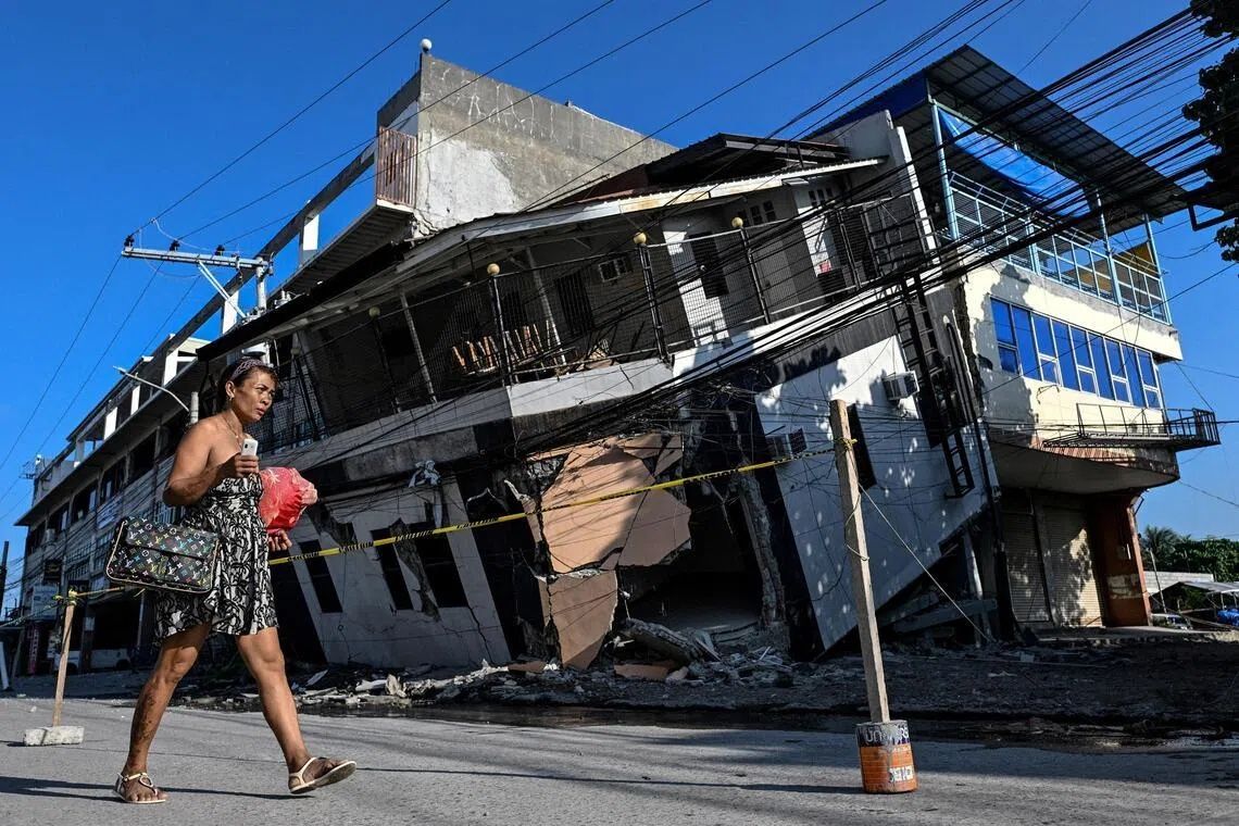
The June 8 earthquake that struck Mindanao's southern coast was unlike anything most residents had witnessed before. With a magnitude of 7.8 and driven by tectonic shifts along the nearby Cotabato Trench, the seismic event proved devastating in its immediate toll—at least 76 people lost their lives and countless structures crumbled to rubble. But beyond the buildings that collapsed and the landslides that scarred hillsides, the disaster left behind a far more permanent and unsettling transformation. In what geophysicists term "coastal uplift," entire sections of the seafloor were thrust upward, fundamentally altering the geography that fishing families and resort operators had known their entire lives.
For Arsenio Butil Jr., a pastor and fisherman living in Glan, Sarangani province, the quake's initial violence gave way to an eerie visual spectacle. As tremors subsided and he ventured toward the shoreline, he witnessed something extraordinary: vast expanses of coral that had been submerged moments earlier now protruded above the waterline. The phenomenon repeated in waves, with the ocean receding and returning several times over, each cycle revealing more dead coral and altered topography. Butil Jr. described watching fish gasping and floating as the water withdrew, a scene that conveyed both the power of geological forces and the ecological disruption such events trigger. What he observed firsthand was the visible manifestation of the Philippine archipelago's position along one of Earth's most seismically active zones.
Scientists at the Philippines' seismology centre confirmed that the transformation was both dramatic and permanent. According to Nane Danlag, a seismology specialist based in General Santos City, the seafloor rose approximately two metres during the event, an elevation that extended the shoreline by as much as 200 metres in certain areas. When plotted on maps, the affected zone stretched across nearly 100 kilometres between two towns, creating a band of newly exposed terrain that would prove contentious for the communities now inhabiting it. Danlag emphasised that while the changes appeared shocking to residents, they represented natural geological processes that have been occurring for millennia. The Cotabato Trench, positioned approximately 50 kilometres offshore from Mindanao, sits at a boundary where Earth's plates collide and grind past one another, a dynamic that periodically releases accumulated tectonic stress through major earthquakes.
The preceding months had offered hints of what was to come. In January, seismologists detected a "swarm" of thousands of predominantly minor tremors in the region, a pattern that prompted the United Nations to issue a disaster risk reduction report in mid-May suggesting these smaller quakes could foreshadow a significant seismic event. Such precursory activity is common along active fault zones, where stress builds progressively before rupture. The June 8 earthquake validated those concerns, demonstrating once again the hazards facing communities in the Philippines' southern regions. For Malaysian and Southeast Asian observers, the incident underscores the broader tectonic vulnerabilities affecting the wider region, where similar plate boundaries extend through Indonesia and beyond.
The transformation of the coastline created immediate humanitarian challenges. Approximately 100 residents, including women and children from nearby villages, fled to elevated terrain when the earthquake struck and remained encamped there days later, unwilling to return to their destroyed homes. Datu Atom Malimpnig, a Maguindanaon chieftain representing the displaced group, articulated the community's lingering anxiety: the newly raised seabed had become an object of fear rather than wonder. Residents remained convinced that the ocean might surge forward with renewed force, wiping away the temporary safety the higher ground had provided. For people whose livelihoods had depended entirely on fishing in familiar waters, the altered coastline represented both physical danger and economic uncertainty. The psychological toll of such displacement extended beyond the immediate destruction; it encompassed profound anxiety about what the reshaped landscape might portend.
The economic ramifications extended beyond fishing communities to the tourism sector. At the Isla Jardin del Mar resort, staff member Edzel Baylon surveyed a fundamentally transformed setting. The establishment had marketed itself as a destination for beach enthusiasts seeking pristine white sand and accessible ocean swimming. Post-quake, however, a wide barrier of jagged, exposed coral now separated the beach from navigable water, rendering the shoreline unusable for the recreational activities that had attracted paying guests. Baylon lamented that the resort's primary commercial asset—its seascape appeal—had been compromised by geological forces beyond any stakeholder's control. For tourism-dependent economies throughout the Philippines and broader Southeast Asia, such natural transformations present existential challenges to established business models and employment patterns.
The scientific community has noted that the Cotabato Trench's position and character make ongoing seismic activity virtually inevitable. The trench represents a zone where tectonic plates meet, and the accumulated energy released during the June 8 quake has been followed by continuous aftershock activity. The Philippine seismology agency recorded more than 8,500 aftershocks in the weeks following the main event, a figure reflecting the profound disturbance to the region's crustal structure. Each tremor, though typically minor, served as a reminder that the earth remained unsettled. Residents and authorities alike faced an uncertain future regarding whether additional major earthquakes might strike and compound existing damage. The prospect of further seismic activity influenced decisions about reconstruction and resettlement planning.
Infrastructural assessments revealed the extent of structural damage that would impede recovery efforts. In Glan, Pastor Butil Jr. noted that ground fissures extended across the landscape, creating conditions he deemed far too hazardous for rebuilding efforts to proceed safely. Long cracks in the earth represented not merely aesthetic damage but genuine structural instability that could worsen if seismic activity resumed. This assessment reflects a critical dimension of post-earthquake recovery: the difficulty of establishing structural integrity in landscapes that have been fundamentally compromised by tectonic movement. Engineers and planners must weigh the costs and feasibility of reconstruction against the ongoing risks that the same geological forces could strike again.
The June 8 earthquake and its consequences carry lessons for the broader Southeast Asian region, where multiple nations sit atop or adjacent to active plate boundaries. The Philippines' experience demonstrates how a single seismic event can simultaneously trigger immediate catastrophic damage and long-term environmental transformation that disrupts established settlement patterns, economic activities, and psychological security. For Malaysian residents, particularly those in Sabah and Sarawak where seismic activity, though less frequent, does occur, the Mindanao case provides sobering perspective on the potential scale of geological hazards. The event also illustrates the complex interplay between natural processes and human systems: what geologists understand as routine tectonic adjustment appears to communities as a terrifying rupture in the familiar world.
The international humanitarian response to the Mindanao earthquake has involved aid agencies providing immediate relief in the form of food assistance, medical care, and shelter provisions. Evacuees in hillside encampments have relied on government workers distributing rice porridge and other essentials while awaiting clarity on whether and when they might safely return to coastal areas. The temporal uncertainty embedded in disaster recovery—not knowing when conditions will stabilise enough for reconstruction—adds psychological strain atop the material losses. Months after the earthquake, fundamental questions about permanent relocation versus phased repatriation remained unresolved, reflecting the complexity of disaster management in regions where geological hazards are recurrent rather than exceptional.
Moving forward, the affected communities face choices about adaptation and resilience. Some residents and officials may pursue elevated settlement patterns, establishing new villages on hillsides where tsunami and earthquake risks appear comparatively reduced. Others might invest in improved construction standards designed to withstand future seismic activity. The permanently altered coastline itself will eventually acquire new ecological equilibrium as marine organisms recolonise the exposed surfaces, potentially creating unfamiliar fishing conditions and opportunities. These longer-term adjustments reflect how natural disasters do not represent isolated disruptions but rather catalysts for fundamental reorganisation of landscapes and human activities. For the Philippines and the wider Southeast Asian region, managing such geological realities remains an ongoing strategic challenge that extends far beyond immediate humanitarian response.

%22%2F%3E%3C%2Fpattern%3E%3C%2Fdefs%3E%3Crect%20width%3D%22100%25%22%20height%3D%22100%25%22%20fill%3D%22url(%23ph7wcvg)%22%2F%3E%3Crect%20width%3D%22100%25%22%20height%3D%22100%25%22%20fill%3D%22url(%23ph7wcvp)%22%2F%3E%3Ctext%20x%3D%2250%25%22%20y%3D%2250%25%22%20text-anchor%3D%22middle%22%20dominant-baseline%3D%22central%22%20fill%3D%22rgba(255%2C255%2C255%2C0.95)%22%20font-family%3D%22Georgia%2C%20'Times%20New%20Roman'%2C%20serif%22%20font-weight%3D%22700%22%20font-size%3D%22194%22%20letter-spacing%3D%22-0.02em%22%3EGerakan%3C%2Ftext%3E%3C%2Fsvg%3E)