Japan faces a compounded weather crisis as two separate typhoons threaten the country simultaneously, forcing authorities to evacuate more than 2 million residents across 13 prefectures by Friday morning. The Japan Meteorological Agency issued its warning on Friday after detecting Typhoon Higos advancing from the Pacific Ocean and Typhoon Mekkhala already impacting the southwestern Amami region in Kagoshima Prefecture. The convergence of these two storm systems presents a rare and dangerous scenario for the densely populated island nation, with meteorologists predicting the dual threat will bring unprecedented rainfall to multiple regions over the coming days.
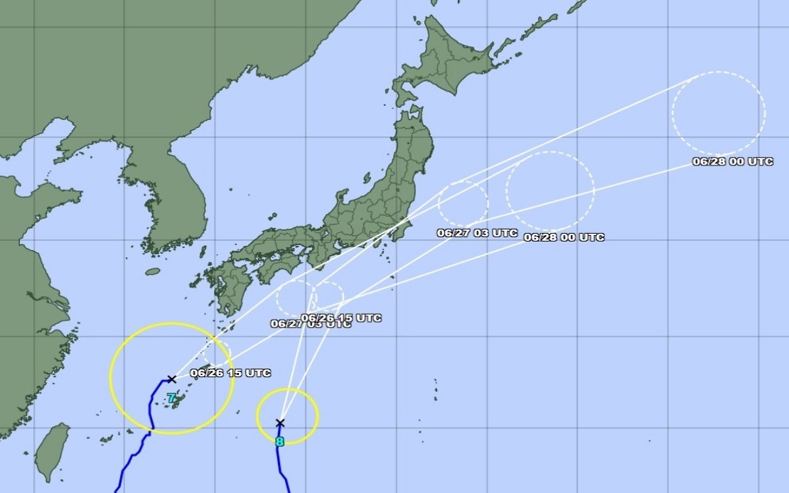
Typhoon Mekkhala was already positioned off the coast near Okinawa's Kume Island as of Friday morning, moving northeast at a measured pace of 15 kilometres per hour. This deliberate progression allows the system to dump sustained precipitation across vulnerable areas rather than pass quickly through. Meanwhile, Typhoon Higos approached from the south and was expected to make landfall the following day, compounding the rainfall impact across already saturated regions. The Japan Meteorological Agency anticipated that while both systems would gradually weaken into extratropical cyclones after making landfall, the window of peak danger would extend through Saturday, with the most intense precipitation occurring during Friday night and early Saturday morning.
The evacuation orders issued by the Fire and Disaster Management Agency underscore the severity of ground conditions across affected prefectures in the Kinki and Kyushu regions. In Seika, Kyoto Prefecture, authorities activated the highest level 5 emergency safety alert after a landslide struck the town early Friday morning, signalling that soil saturation had already reached critical thresholds. This early warning proved prescient given the rainfall statistics documented by the meteorological agency. Between Tuesday and Friday morning alone, Goto in Nagasaki Prefecture accumulated 600 millimetres of rain, while Aso in Kumamoto Prefecture and Ureshino in Saga Prefecture each recorded more than 500 millimetres, establishing baseline conditions of extreme water-logged terrain before either typhoon made direct impact.
The distribution of rainfall across Japan's geography reveals why authorities feared cascading natural disasters. Heavy precipitation had already begun falling across western and eastern regions by Friday, establishing a worrying pattern that meteorologists expected would intensify dramatically as the two typhoons interacted with existing atmospheric moisture. The agency issued specific warnings about the Okinawa Prefecture and eastern Japan regions, recognising these areas faced the most immediate threat from the approaching systems. As Typhoon Higos moved northward along Japan's southern coast, rainfall forecasters predicted that the Tokai and Kanto regions would experience a substantial intensification beginning Friday and persisting through Saturday.
Quantitative precipitation forecasts provided by the Japan Meteorological Agency offered concerning specificity about the scale of additional rainfall expected. The Tokai region faced projections of up to 300 millimetres by noon Saturday, representing a significant additional burden on already saturated catchments and drainage systems. The Kanto-Koshin region was forecast to receive up to 150 millimetres, a figure that might appear modest in isolation but carried grave implications when layered atop existing rain accumulation. For Malaysian readers accustomed to tropical rainfall patterns, these figures may seem familiar, yet Japan's infrastructure—including aging drainage systems in some older urban areas and mountainous terrain prone to slides—creates heightened vulnerability to rapid-onset flooding and debris flows.
The synchronised approach of two distinct typhoon systems presented weather forecasters with complex modelling challenges and residents with unprecedented risk exposure. Typically, a single typhoon passage allows emergency services to concentrate resources and citizens to prepare for a discrete weather event with defined arrival and departure windows. The presence of Mekkhala already in the region while Higos approached meant that rainfall would not concentrate in time but rather extend across an expanded temporal window, with consequences for reservoir management, river discharge, and ground saturation dynamics. Emergency management officials had to contend with the possibility that decisions made to cope with one system could prove inadequate once the second system's effects compounded the initial impact.
Regional economic implications extended beyond the immediate safety concerns. Japan's manufacturing sector, particularly in areas like the Kanto region, depends on operational continuity, and weather-related disruptions to supply chains would ripple through regional production networks. Agricultural sectors in affected prefectures faced crop damage risks and potential soil degradation from excessive runoff. For Southeast Asian nations including Malaysia that maintain significant trade relationships with Japan, any disruption to transportation networks or manufacturing capacity would carry tangible consequences for regional commerce and supply chain stability.
The meteorological agency's assessment that both typhoons would weaken into extratropical cyclones offered qualified reassurance, yet this transition carried its own hazards. Transitioning tropical cyclones often become slower-moving systems that linger over regions, perpetuating heavy rainfall long after the initial storm surge danger passes. The distinction between tropical and extratropical classification, while significant from a meteorological standpoint, offered little comfort to residents facing days of continuous precipitation and mounting flood risks. Authorities emphasised sustained vigilance rather than declaring an imminent return to normal conditions once the systems technically downgraded.
Historical context reinforced contemporary concern about this scenario. Multiple-typhoon events remain statistically uncommon but carry disproportionate consequences when they occur. Japan's experience with such events has shaped early warning systems and evacuation protocols, yet the simultaneous presence of two systems still represented a significant operational challenge. The evacuation of over 2 million people from 13 prefectures simultaneously required coordination across multiple prefectural governments, with shelter capacity, transportation logistics, and communication systems all pressed to capacity.
The broader atmospheric pattern that allowed two typhoons to develop and approach Japan simultaneously reflected larger seasonal and climatic conditions. Late June positioning in the Western Pacific typhoon belt creates conditions where multiple systems can develop in geographic proximity. Climate change discussions in Japan have increasingly focused on whether such multiple-system scenarios might increase in frequency, a prospect with profound implications for disaster preparedness and infrastructure resilience. Emergency planners recognised that singular worst-case scenarios were giving way to consideration of compounded risks requiring enhanced preparation.